Earth Revealed: A Journey Through Extraordinary Geological Wonders and Modern Satellite Surveillance

The surface of the Earth is a canvas of immense geological complexity and shifting ecosystems, viewed increasingly through the high-resolution lens of modern satellite technology. From the depths of the Atlantic to the arid basins of Africa and the historic architecture of the Nile Valley, the planet’s features tell a story of billions of years of tectonic activity, climate cycles, and human intervention. Recent imagery, ranging from deep-sea volcanic eruptions to the seasonal bloom of microorganisms in the Baltic Sea, provides scientists and the public alike with a comprehensive look at the physical forces that continue to shape our world.
Oceanic Anomalies and Submerged Landscapes
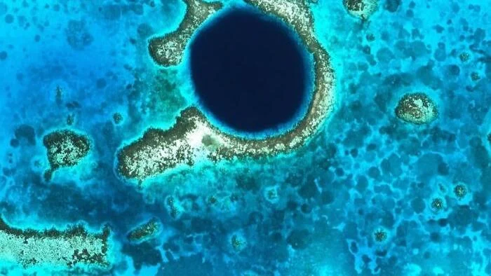
One of the most iconic marine landmarks is the Great Blue Hole, a near-perfect circular marine sinkhole situated in the center of Lighthouse Reef, approximately 70 kilometers off the coast of Belize. Measuring roughly 300 meters in diameter and reaching a depth of 125 meters, this site was once a dry limestone cave system during the last glacial period, when global sea levels were significantly lower. As the ocean levels rose, the cavern flooded and eventually collapsed, creating the vertical abyss seen today. Recognized globally as one of the premier destinations for deep-sea diving, the site serves as a vital record of prehistoric climate and sea-level history.
In stark contrast to the depths of the Caribbean, the Hara Forest in Iran showcases the resilience of coastal ecosystems. Located between Qeshm Island and the mainland, this mangrove forest constitutes the largest such ecosystem in the Persian Gulf. Protected as a biosphere reserve since 1972, the area is a critical habitat for migratory species, including flamingos, pelicans, and herons, while also serving as a foraging ground for endangered green sea turtles. Satellite surveillance highlights the intricate, branching waterways that sustain this biodiversity, underscoring the importance of managed environmental conservation in the face of regional industrial expansion.
Volcanic Resurgence in the Bismarck Sea
The dynamic nature of the Earth’s crust was underscored on May 8, 2026, when seismic activity beneath the Bismarck Sea signaled the awakening of a previously dormant submarine volcano. Situated approximately 125 kilometers southeast of Manus Island, the event was captured by regional sensors and orbital satellites, which within 24 hours detected a steam plume rising nearly three kilometers above the ocean surface.
Geologists attribute the eruption to the Titan Ridge, an underwater tectonic feature that has long been a subject of interest for Pacific seismic researchers. The rapid emergence of this plume demonstrates the utility of satellite-based Earth observation in monitoring remote maritime regions where traditional ground-based monitoring stations are impractical. Scientists emphasize that such eruptions are part of the broader, ongoing tectonic reconfiguration of the Bismarck Plate, though they pose little immediate threat to populated areas on nearby islands.
Space-Based Observations and Atmospheric Perspectives
The integration of advanced satellite technology, such as the Himawari-9 weather satellite operated by the Japan Meteorological Agency, has revolutionized our ability to observe celestial mechanics. On October 23, 2026, at 00:20 UTC, the satellite, orbiting 35,800 kilometers above the equator, captured a rare visual alignment of the Moon crossing the edge of its field of view.
While the image creates the illusion of proximity, the scientific reality reflects the immense scale of the Earth-Moon system, with a distance of approximately 384,000 kilometers separating the two bodies. These high-frequency captures—occurring every ten minutes—allow meteorologists to track complex atmospheric patterns and cloud formations, providing critical data for global weather forecasting models and climate research.
Arid Landscapes and Earth’s Geological Memory
The northwestern reaches of Namibia present a landscape so stark and colored by mineral diversity that it is frequently compared to the surface of Mars. Satellite imagery utilizing false-color mapping reveals the Ugab River as it snakes through an intensely arid environment, characterized by jagged ridges and varying rock compositions. These visual representations are essential for geological mapping, allowing researchers to identify mineral deposits and understand the erosional history of the region without needing to conduct extensive, labor-intensive ground surveys.
Similarly, the Flinders Ranges in South Australia offer a study in geological stratification. Covering roughly 1,257 square kilometers, the region’s psychedelic appearance in satellite imagery is a result of varying rock types reflecting different light spectrums. These ranges are a repository of ancient biological history, containing some of the most significant fossil records from the Ediacaran period, which marks the emergence of complex life forms over 500 million years ago.
Perhaps the most famous geological formation is the Richat Structure, commonly referred to as the "Eye of the Sahara," located in Mauritania. Formed roughly 100 million years ago, the structure is a deeply eroded geological dome. Initially, molten rock pushed the earth’s crust upward; over tens of millions of years, wind and water eroded the softer layers, leaving behind a series of concentric rings of resistant quartzite. Its distinct, massive geometry—visible from low Earth orbit—made it a vital navigational landmark for early space missions, serving as an orientation guide for astronauts long before the advent of modern GPS.
Historical Preservation and Human Geography
Human history is etched into the landscape as clearly as geological features, most notably in the Giza Plateau of Egypt. Aerial and satellite photography allow for the precise mapping of the Giza necropolis, where the Great Pyramid of Khufu, the pyramid of Khafre, and the pyramid of Menkaure stand alongside smaller structures built for royal families.
The Great Pyramid, constructed approximately 4,500 years ago, represents a pinnacle of ancient engineering. For nearly 3,800 years, it held the title of the tallest human-made structure on the planet. Its precise alignment to the cardinal directions remains a subject of study, highlighting the advanced astronomical and mathematical knowledge of the Old Kingdom. Satellite-based monitoring is currently being used to assess structural stability and monitor for unauthorized site encroachment, ensuring the preservation of these heritage sites for future generations.
Ecological Shifts and Biodiversity
In the northern reaches of the globe, the Swedish island of Gotland serves as a barometer for the health of the Baltic Sea. Satellite data frequently captures vast, swirling green patterns surrounding the island, which are blooms of cyanobacteria, often referred to as blue-green algae. These blooms are a seasonal phenomenon, driven by the influx of nutrients—primarily nitrogen and phosphorus—into the sea, often stemming from agricultural runoff. While natural in occurrence, the increasing frequency and scale of these blooms are a point of concern for environmental regulators, as they can lead to oxygen-depleted "dead zones" that threaten marine life.
In the southern hemisphere, the contrast between the dark, deep waters of Lake Tanganyika and the vibrant, protected canopy of the Gombe Stream National Park in Tanzania illustrates the intersection of geography and conservation. Gombe, covering only 20 square miles, is one of the smallest national parks in the world but holds massive scientific significance as the site of Jane Goodall’s groundbreaking chimpanzee research. Satellite observation of this area is critical for monitoring the impact of surrounding land-use changes on the park’s isolated habitat, emphasizing the necessity of maintaining "green corridors" for wildlife migration.
The Broader Implications of Earth Observation
The data derived from these disparate locations—from the underwater volcanoes of the Bismarck Sea to the ancient pyramids of Egypt—share a common thread: the necessity of remote sensing in understanding our evolving world. As satellite resolution increases, so does our capacity to manage natural resources, mitigate disaster risks, and preserve cultural heritage.
Current analysis suggests that the continued integration of multispectral imaging will allow for more precise tracking of climate-driven shifts in flora and fauna, as well as the early detection of geological hazards. For instance, the rapid response to the Titan Ridge volcanic activity demonstrates that modern orbital infrastructure is no longer just a tool for navigation, but a frontline defense system for monitoring the physical integrity of the planet.
As we move further into the 21st century, the ability to synthesize data from these diverse geographical locations will be paramount. Whether it is tracking the nitrogen levels in the Baltic Sea to prevent ecological collapse or utilizing orbital imagery to protect the structural integrity of historical monuments, the "view from above" has become the most essential tool in the modern scientific arsenal. The Earth, in all its complexity, remains a dynamic entity, and our capacity to observe it from the vacuum of space provides the necessary insight to ensure the stability of the ecosystems upon which we all depend.