NASA Monitors Volcanic Activity of Anak Krakatau as Geological Agency Maintains Alert Level III Status

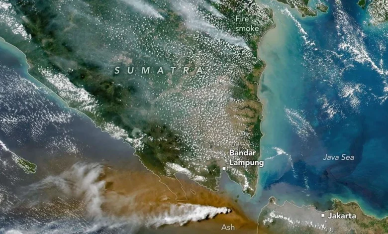
The United States National Aeronautics and Space Administration (NASA) has intensified its orbital surveillance of the Anak Krakatau volcano, tracking a significant eruptive phase that began in early September 2026. Through a sophisticated array of satellite-based sensors, the agency has provided critical data regarding the composition, density, and atmospheric impact of the plumes emitted by the restless volcano, which remains under the close watch of Indonesian authorities.
Since September 5, 2026, NASA’s Earth-observing satellites have captured high-resolution imagery and spectral data documenting the volcano’s output. The data, primarily sourced from the Landsat 8 satellite and the NOAA-20 platform, highlights the complexity of the eruption, which has transitioned through various phases of intensity, manifesting as both ash-heavy columns and gas-rich emissions.
Orbital Insights: Analyzing the Plume Composition
The monitoring effort has utilized the Operational Land Imager (OLI) aboard the Landsat 8 satellite to produce visual evidence of the ongoing volcanic activity. These images reveal distinct gnarled plumes of volcanic gas, characterized by bright white hues, interspersed with darker, brownish ash clouds. The contrast between these materials provides volcanologists with a clearer understanding of the eruptive dynamics at play beneath the surface.
Complementing this visual data, the Visible Infrared Imaging Radiometer Suite (VIIRS) instrument on the NOAA-20 satellite has allowed for a deeper atmospheric analysis. NASA’s scientific records indicate that the aerosol index—a measure of the light-absorbing properties of particles in the atmosphere—has surged. Specifically, measurements taken at the 380-nanometer wavelength show index values ranging from 10 to 20, represented in satellite heat maps by deep yellow, orange, and red gradients.
This high aerosol index confirms a significant concentration of fine particulate matter, including volcanic ash, suspended in the atmosphere. The agency further noted a marked increase in sulfur dioxide (SO2) column density within the upper troposphere and lower stratosphere. In satellite visualizations, this chemical concentration is identified by high-intensity blue-to-white gradients, indicating that the volcanic plume has successfully reached significant altitudes, posing potential concerns for regional air quality and atmospheric chemistry.
The Geological Context: Anak Krakatau’s Historical Volatility
Anak Krakatau, the "Child of Krakatau," occupies a geologically precarious position within the Sunda Strait. It emerged from the caldera of the legendary 1883 eruption of Krakatau, which remains one of the most violent volcanic events in recorded history. Since its emergence in 1927, the volcano has been in a state of nearly constant growth, punctuated by periodic, violent eruptive episodes.
The 2026 event is not an isolated incident but rather the latest in a series of resurgences. Volcanologists emphasize that the architecture of Anak Krakatau is inherently unstable; because the mountain is built on a steep, submarine slope, its growth is often accompanied by structural failures, most notably the devastating flank collapse in December 2018, which triggered a deadly tsunami. Consequently, global monitoring agencies like NASA and local bodies like the Center for Volcanology and Geological Hazard Mitigation (PVMBG) treat even moderate activity with extreme caution.
Chronology of the September 2026 Eruptive Phase
The escalation of activity in early September followed a period of relative quiescence. By September 5, satellite data confirmed that the volcano had entered a more aggressive phase of ash emission. Throughout the following week, the eruption intensity fluctuated.
By September 11, 2026, the Geological Agency of the Indonesian Ministry of Energy and Mineral Resources (ESDM) observed a notable shift in the eruptive style. The volcano transitioned into what is classified as a "Strombolian" eruption. This type of activity is defined by rhythmic, intermittent bursts of gas and magma, which propel incandescent lava bombs and ash clouds into the air. Unlike more explosive, sustained Plinian eruptions, the Strombolian phase is characterized by the relatively orderly release of pressure from the magmatic conduit.
However, the agency maintained the status of the volcano at Level III (Siaga/Alert), the second-highest level on Indonesia’s four-tier volcanic alert system. This decision reflects a cautious approach, acknowledging that while the surface activity has transitioned to a rhythmic state, the underlying seismic indicators suggest that the reservoir remains highly pressurized.
Seismic Analysis and Magmatic Supply
The official report from the Geological Agency highlights a divergence between surface observations and deep-seated seismic activity. While the visual eruption appears to have "settled" into a predictable Strombolian pattern, the seismic records tell a more complex story.
Technicians have reported an increase in low-frequency earthquakes and "hybrid" seismic events. Hybrid earthquakes are particularly concerning to geologists because they typically indicate the movement of fluids—such as magma and gases—through rigid rock at depth. When compared to the historical baseline for Anak Krakatau, the current frequency of these tremors is elevated.
This sustained seismic signature suggests that the volcano is being fed by an active supply of magma from deeper crustal reservoirs. This continuous recharge mechanism is the primary reason for the persistent Level III status. Experts warn that the current eruptive state could either taper off gradually or escalate rapidly if the magmatic supply increases or if the conduit becomes obstructed, leading to a pressure build-up.
Broader Implications and Public Safety
The collaboration between NASA and local Indonesian agencies underscores the importance of multi-modal monitoring in modern volcanology. By combining ground-based seismic data with satellite-based remote sensing, authorities can create a more holistic model of volcanic behavior. This integrated approach is essential for regional disaster mitigation, particularly regarding aviation safety.
The sulfur dioxide and ash plumes documented by NASA serve as a warning for the aviation industry. Volcanic ash can cause catastrophic failure in jet engines, while sulfur dioxide concentrations can impact flight paths in the vicinity of the Sunda Strait, one of the busiest maritime and air corridors in Southeast Asia.
For the surrounding coastal communities in Banten and Lampung, the current situation necessitates ongoing vigilance. Although the eruptions are currently contained within the immediate vicinity of the crater, the threat of potential tsunamis—a historical hallmark of the Krakatau complex—remains a core focus for regional civil defense authorities. The Indonesian government has maintained exclusion zones around the island, prohibiting tourism and fishing activities within a specified radius to prevent casualties during sudden eruptive bursts.
Future Outlook and Scientific Cooperation
As the world continues to watch the evolution of the 2026 eruption, the synergy between space-based observation and terrestrial monitoring remains vital. NASA’s Earth Observatory continues to process and release data that allows the global scientific community to study the life cycle of the volcano in real-time.
Looking forward, the persistence of the Strombolian phase suggests that Anak Krakatau will continue to dominate the landscape of the Sunda Strait for the foreseeable future. The combination of sustained seismic activity and atmospheric emissions indicates that the volcano has not yet reached a state of long-term stability. Authorities have urged the public to rely exclusively on official updates from the Geological Agency, as the transition between eruptive phases can occur with little warning.
The ongoing monitoring effort serves as a reminder of the dynamic nature of the Ring of Fire. As geological processes continue to reshape the island, the integration of high-tech surveillance and on-the-ground expertise will remain the primary defense in mitigating the inherent risks posed by one of the world’s most active and historically significant volcanic structures. Whether this phase leads to a further period of growth or a temporary lull in activity remains to be seen, but the data collected by NASA since early September provides an indispensable record of a planet in constant, volcanic flux.