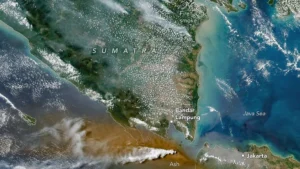
Joint Search and Rescue Operation Intensifies as Five Journalists and Three Crew Members Remain Missing Near Mount Anak Krakatau in the Sunda Strait

Entering the critical third day of operations, a joint Search and Rescue (SAR) team has significantly ramped up its efforts to locate five journalists and three other individuals who went missing while covering the volcanic activity of Mount Anak Krakatau. The incident, which unfolded in the volatile waters of the Sunda Strait, has triggered a massive multi-agency response involving naval assets, aerial units, and local government disaster management agencies. As the operation presses forward under hostile environmental conditions, the search teams face a relentless combination of heavy volcanic ash, high-velocity winds, and treacherous maritime swells that continue to complicate rescue efforts.
The missing group was traveling in a high-speed watercraft, commonly referred to as a speedboat, on Monday, September 7, 2026. Their mission was to document the escalating geological activity of Mount Anak Krakatau, a notoriously unpredictable volcanic island situated in the middle of the Sunda Strait between the islands of Java and Sumatra. The island, which sits atop the remnants of the catastrophic 1883 eruption of Krakatoa, has been under a heightened state of alert due to frequent phreatic and magmatic eruptions. When the vessel failed to return by evening and all attempts at electronic communication proved futile, authorities were notified, prompting the immediate mobilization of emergency response teams.
By Thursday, September 10, 2026, the scale of the operation expanded dramatically. Recognizing the vast potential drift zone dictated by local currents and wind patterns, the joint SAR team widened the search grid to encompass six distinct sectors. The cumulative search area now spans an impressive 2,483 square nautical miles across the Sunda Strait. This massive expansion reflects both the urgency of the mission and the calculated drift models utilized by maritime search experts to predict the movement of floating objects or distressed vessels in open water.
Adverse Environmental and Volcanic Hazards Hampering Operations
The search and rescue teams operating in the Sunda Strait are confronting a multilayered crisis dictated by both meteorological and geological extremes. The primary hazard stems from Mount Anak Krakatau itself, which remains active at Level III (Siaga, or Standby). The volcano continues to spew particulate matter, resulting in dense blankets of volcanic ash that drift across the surrounding waters. This airborne debris not only reduces visibility for spotters on rescue vessels and aircraft but also poses mechanical and respiratory risks. Marine units are frequently forced to alter their navigation routes dynamically, tracking shifting wind patterns to avoid dense ash plumes that could damage engine intakes or endanger personnel.
In the early phases of the operation, SAR units concentrated their grid sweeps around several small islands in the immediate vicinity of the volcano, including Pulau Rakata, Krakatoa Kecil, and Pulau Panjang. These landmasses lie within a three-kilometer radius of the active crater, designated as an exclusion zone due to the high risk of sudden pyroclastic surges, ballistic projectile ejections, and localized tsunami waves triggered by submarine collapses. Operating within this hazardous zone demands extreme tactical caution from the naval and civilian rescue personnel deployed to the area.
Compounding the volcanic hazards are severe marine weather conditions. Throughout the operation, rescue teams have battled persistent high-velocity winds that whip up rough seas across the Sunda Strait. Wave heights consistently ranging between one and two meters create a turbulent environment that severely hampers visual scanning from smaller rubber boats and rigid-hull inflatable boats (RHIBs). Furthermore, these dynamic sea states necessitate complex navigational calculations. SAR coordinators must constantly factor in how surface currents and wind drag could displace the missing speedboat or any survivors far from the vessel’s last known waypoint.
Multi-Agency Deployment and Aerial Reconnaissance
To maximize coverage and overcome the vast expanse of the search grid, the National Search and Rescue Agency (Basarnas), in coordination with the Indonesian Navy (TNI AL) and regional disaster management boards, has deployed a combination of surface vessels and specialized aviation assets. The mobilization transitioned from a purely coastal search into an integrated, multi-dimensional operation combining maritime patrol craft and high-performance rotary-wing aircraft.
On Thursday afternoon, a state-of-the-art Dauphin AS365 N3+ helicopter bearing registration number HR-3604 joined the aerial search grid. Departing from Atang Sendjaja Air Force Base in Bogor, West Java, at approximately 12:36 PM Western Indonesia Time (WIB), the twin-engine aircraft was tasked with executing low-altitude visual sweeps across remote sectors that are difficult for surface vessels to monitor efficiently. Equipped with advanced stabilization and observation capabilities, the helicopter allows search coordinators to survey extensive ocean tracts in a fraction of the time required by ships. Despite the intensive aerial sorties flown throughout the day, initial reports from Basarnas confirmed that the flight crews had not yet spotted the missing vessel or its occupants from the air.
Concurrently, maritime assets have been combing the waters systematically. Among the deployed naval units is the Indonesian Navy vessel KAL Anyer 1-3-64, which has been assigned to patrol designated high-priority sectors within the broader 2,483-square-nautical-mile search zone.
Discovery of Marine Debris Sparks Verification Efforts
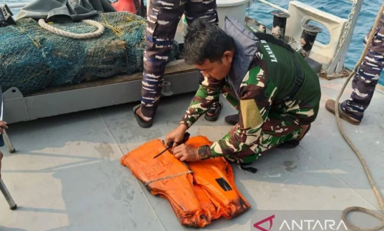
A critical development occurred during the afternoon of Thursday, September 10, injecting both urgency and cautious anticipation into the search operation. At approximately 3:32 PM WIB, the crew aboard KAL Anyer 1-3-64 recovered a standard marine life jacket floating in the open water. The discovery was made approximately 7.5 nautical miles west of the Tanjung Koneng Anyer lighthouse, which translates to roughly 20 nautical miles northeast of Mount Anak Krakatau’s active crater.
In addition to the life jacket, naval personnel spotted a white cylindrical container resembling a makeshift or secondary flotation device in the immediate vicinity. These findings immediately prompted a localized concentration of search vessels around the recovery coordinates to scour the surrounding currents for any additional debris, personal belongings, or distress signals.
However, military and rescue officials have maintained a disciplined stance regarding the discovery. Head of Basarnas Mohammad Syafii emphasized that the recovered life jacket and container cannot be definitively linked to the missing journalists until a thorough forensic and administrative verification process is completed. The TNI AL has handed the items over to identification teams to cross-reference serial numbers, manufacturing batches, and any identifying marks with the equipment inventory or personal belongings known to have been carried by the media contingent and boat crew.
Institutional Reactions and Broader Implications
The disappearance of the five journalists alongside three accompanying personnel has sent shockwaves through Indonesia’s media landscape and disaster response community. The tragedy underscores the inherent risks faced by media professionals who venture into active disaster zones to report on natural phenomena. In the wake of the incident, the National Board for Disaster Management (BNPB) issued a formal statement expressing deep concern and solidarity with the families of the missing individuals. BNPB highlighted the vital role that journalists play in educating the public about geological hazards, while simultaneously reiterating the critical need for adherence to safety protocols when reporting near active volcanoes.
Similarly, the Provincial Government of Banten has actively coordinated with central authorities to support the logistical demands of the expanded search operation. Regional agencies have mobilized local fishermen and coastal community networks along the western coastline of Java to serve as supplementary eyes and ears, instructing them to report any unusual debris washing ashore or sightings of drifting watercraft.
From a strategic perspective, this incident highlights the complex challenges inherent in maritime disaster response within archipelagic waters. The Sunda Strait is one of Indonesia’s busiest and most hydrographically demanding sea lanes, characterized by strong tidal currents, heavy commercial maritime traffic, and proximity to volatile geological faults and volcanoes. The protracted nature of the search operation—constrained by the legal framework governing standard seven-day SAR mandates—places immense psychological and logistical pressure on the responding agencies.
As the operation enters its subsequent phases, Head of Basarnas Mohammad Syafii has assured the public that search assets will remain fully optimized throughout the mandated seven-day operational window. While the clock ticks down on the optimal survival window for individuals adrift at sea, the joint SAR team continues to adjust its tactical deployment based on real-time meteorological data, drift trajectory modeling, and the ongoing analysis of recovered marine debris. For the families of the missing journalists and crew members, as well as the broader journalistic community across the archipelago, the coming days will remain a period of intense anxiety as the search in the shadow of Anak Krakatau presses relentlessly forward.
Related posts: